
Chandrayaan-2 DFSAR Reveals Subsurface Ice in Lunar South Polar Craters
Overview
Scientists from the Physical Research Laboratory (PRL), Ahmedabad, have used radar observations from ISRO's Chandrayaan-2 spacecraft to investigate the presence of subsurface water-ice in a special class of craters near the Moon's South Pole. The study, published on May 6, 2026, in npj Space Exploration (Nature portfolio), presents strong radar-based evidence for subsurface ice in four out of nine craters examined — with one crater showing the most compelling combined evidence seen to date in lunar polar radar research.
Background: Permanently Shadowed Regions and Cold Traps
The Moon's axial tilt is only about 1.5°, which means sunlight barely reaches the polar regions. Crater floors near the poles that never receive direct sunlight are called Permanently Shadowed Regions (PSRs). Without any solar heating, temperatures inside PSRs can drop below 110 K (−163°C) — cold enough for water-ice to remain stable against sublimation over geological timescales.
Over the past two decades, a range of instruments — neutron spectrometers, ultraviolet imagers, near-infrared spectrometers, thermal radiometers, and laser reflectometers — have built up a body of evidence pointing to surface and subsurface water-ice within PSRs. The LCROSS mission provided direct in-situ confirmation when it impacted Cabeus crater in 2009 and detected water in the ejecta plume.
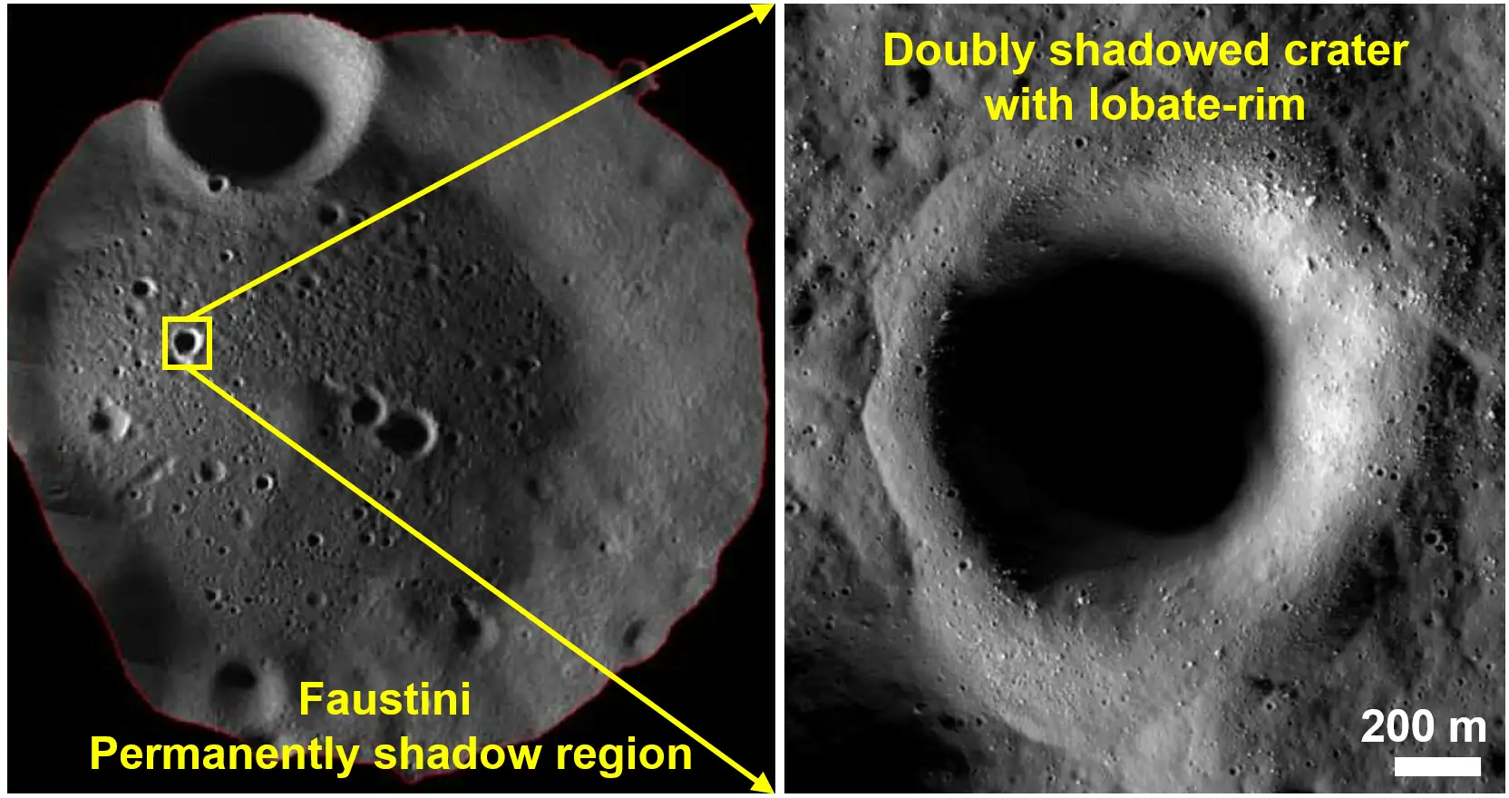
Within PSRs, there is a smaller, even colder sub-category: doubly shadowed craters.
What Are Doubly Shadowed Craters?
A doubly shadowed crater is a smaller crater located inside a larger PSR crater. Its raised rim provides an additional layer of shielding — blocking not only direct sunlight (which the host PSR already blocks) but also the scattered sunlight and thermal radiation emitted by nearby sunlit terrain outside the host crater.
This double shielding drives interior temperatures down to approximately ~25 K (−248°C), making these among the coldest environments in the Solar System. Thermal models predict they are among the most stable long-term cold traps for volatile retention on the Moon.
Three large craters near the lunar South Pole host known doubly shadowed sub-craters:
- Haworth (~51 km diameter) — hosts 3 doubly shadowed craters (H1, H2, H3)
- Shoemaker (~52 km diameter) — hosts 3 doubly shadowed craters (S1, S2, S3)
- Faustini (~41 km diameter) — hosts 4 doubly shadowed craters (F1, F2, F3, F4)
Faustini holds the largest total doubly shadowed area (0.564 km²), followed by Shoemaker (0.446 km²) and Haworth (0.308 km²). Radar data was unavailable for crater F4, so the study focuses on nine craters.
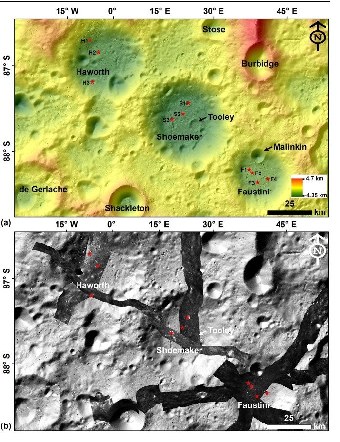
Fig. 1 — South Pole location map] The top panel shows a colour-coded elevation map of the Moon's South Polar Region, with red star symbols marking the locations of all doubly shadowed craters studied — H1, H2, H3 within Haworth; S1, S2, S3 within Shoemaker; and F1, F2, F3, F4 within Faustini. Warmer colours (red/orange) indicate higher elevations; cooler colours (green/yellow) indicate lower terrain. The bottom panel shows the same region through Chandrayaan-2 DFSAR radar coverage, with dark swaths representing the permanently shadowed areas where radar data was collected. Together these panels show that the study craters sit deep within the three largest PSR host craters close to the South Pole.
The Instrument: Chandrayaan-2 DFSAR
The Dual Frequency Synthetic Aperture Radar (DFSAR) onboard Chandrayaan-2 is the first fully polarimetric SAR instrument deployed to study the Moon. Developed by ISRO's Space Applications Centre (SAC), Ahmedabad, it operates at two wavelengths:
- L-band — longer wavelength, greater subsurface penetration
- S-band — shorter wavelength, sensitive to shallower layers
It captures radar returns in four polarization combinations — HH, HV, VH, and VV — enabling detailed characterisation of scattering mechanisms. Its spatial resolution of 2–75 metres per pixel is higher than earlier lunar radar instruments such as Mini-RF on NASA's Lunar Reconnaissance Orbiter or Mini-SAR on Chandrayaan-1.
The Radar Parameters: CPR and DOP
Two parameters are central to this study:
Circular Polarization Ratio (CPR)
CPR is the ratio of radar returns in the same circular polarization as the transmitted signal to those in the opposite polarization.
- CPR < 1: Typical of dry regolith (surface scattering)
- CPR > 1: Associated with volumetric scattering — consistent with ice
Water-ice allows radar waves to scatter multiple times within the medium, returning significant energy in the same polarization as transmitted, pushing CPR above 1.
Degree of Polarization (DOP)
DOP measures how much the reflected radar signal retains its original polarization state.
- High DOP: Signal bounced cleanly off a surface — typical of rough, rocky terrain (double-bounce scattering from boulders)
- Low DOP (approaching 0): Signal heavily scrambled — typical of volumetric scattering through ice
The key methodological advance in this study is combining both metrics. Previous studies used CPR alone, which led to ambiguity — rough, blocky crater walls also produce CPR > 1. The team establishes a refined diagnostic criterion: CPR > 1 combined with DOP < 0.13 provides a reliable indicator of subsurface ice through volumetric scattering. This is a tighter threshold than the previously proposed DOP < 0.35.
Crater Morphology and Topography
Before examining the radar data, the team characterised the physical shape of each crater using ShadowCam imagery and LOLA Digital Elevation Models (DEMs).
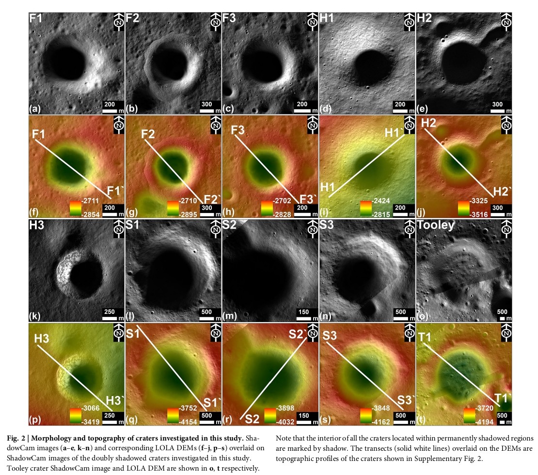
Fig. 2 — ShadowCam + DEM morphology grid] Each crater is shown twice — the upper row of each pair is a ShadowCam greyscale image of the surface, and the lower row is a colour-coded elevation map (DEM) of the same crater, where green represents the deepest areas and red/orange the raised rims and walls. The white diagonal lines on the DEMs are topographic transects used to measure wall slopes and depth profiles. Crater F2 (second from top-left) shows a noticeably asymmetric, irregular rim compared to the more circular F1 beside it — this is the lobate-rim morphology that indicates subsurface ice involvement during formation. The interior floors of all craters appear completely black in the ShadowCam images, confirming their permanently shadowed status. Larger craters S1 and S3 show gentler slopes and less boulder concentration, suggesting they are older and more eroded than the smaller craters.
The craters range from 700 m (F3) to 7,050 m (Tooley) in diameter. Smaller craters F2, F3, H1, and H3 have steeper walls (18°–29°), while larger craters S1 and S3 have gentler slopes (13°–16°), suggesting greater age and erosion. Crater F2 is notable for its prominent lobate rim. Crater H3 lacks a lobate rim but is surrounded by extensive impact melt flows extending 3–5 crater radii from its rim.
Results: Radar Signatures Across Nine Craters
DFSAR observations show elevated CPR (>1) in the interiors of four doubly shadowed craters: F2, F3, H3, and S1. These same four craters also show consistently low DOP values of 0.1–0.13 — meeting the refined ice criterion.
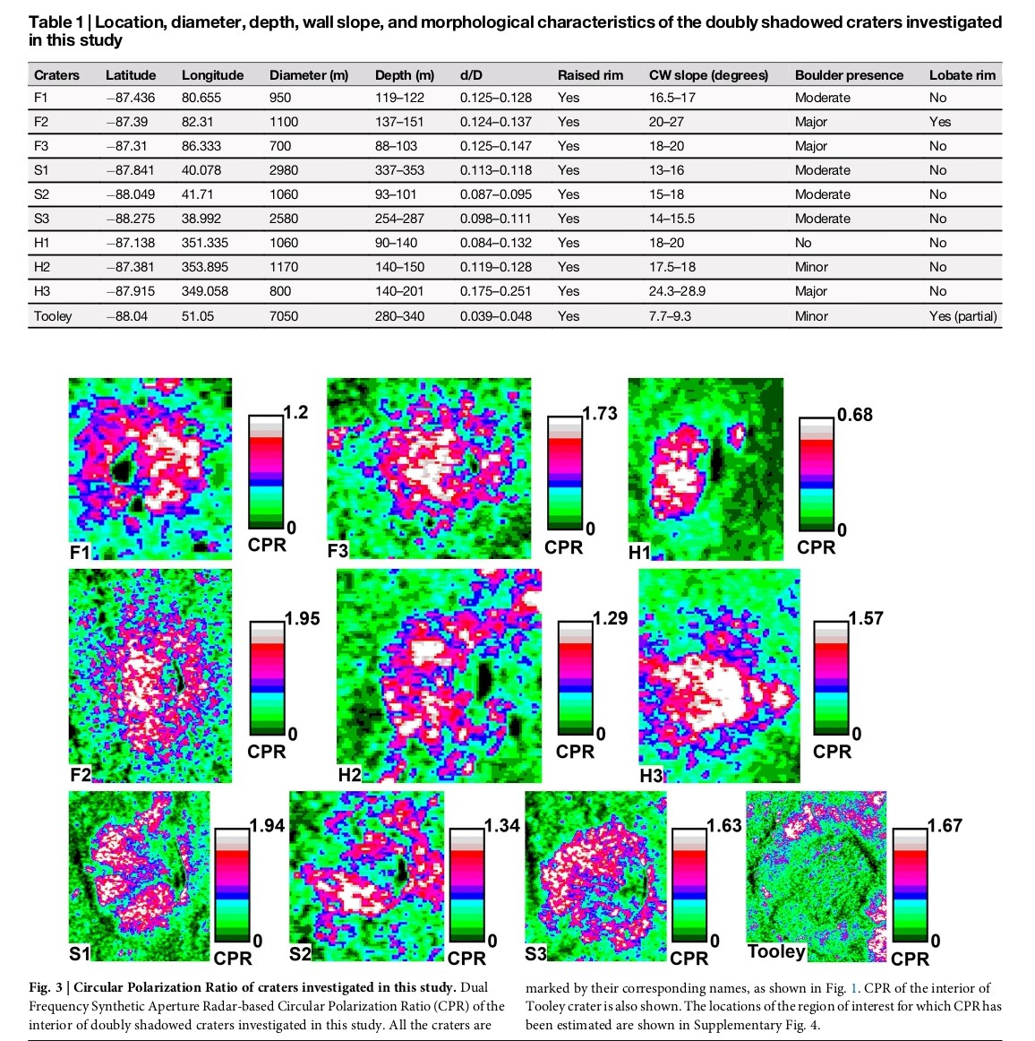
Fig. 3 — CPR colour maps] These are CPR maps derived from Chandrayaan-2 DFSAR data for each crater. The colour scale runs from 0 (green, low CPR = dry regolith) through blue and pink to white (highest CPR = strongest ice signal). White and pink pixels indicate CPR > 1 — the radar signature associated with volumetric scattering from ice. Crater F2 stands out clearly, with the largest concentration of white/pink pixels covering ~47% of its interior and a peak CPR of 1.95. Crater F3 follows with ~42% coverage. In contrast, craters H1, S2, S3, and Tooley show predominantly green — low CPR throughout, consistent with dry regolith and no ice signal. Note also that the Table 1 above the maps lists the physical properties of all craters — diameter, depth, wall slope, boulder presence, and lobate rim status. F2 is the only crater with a confirmed lobate rim, which alongside its radar signature makes it the strongest ice candidate in the study.
Craters F2 and F3 show the highest fractions of elevated CPR pixels — about 47% and 42% of their interiors respectively. The peak CPR was 1.95 in F2, followed by 1.94 in S1, 1.73 in F3, and 1.57 in H3. Although S1 reaches a peak comparable to F2, the number of elevated pixels in F2 is about six times higher. Craters H1 and Tooley showed no elevated CPR at all.
Refining the Radar Criterion: CPR + DOP Together
Elevated CPR alone is not sufficient proof of ice — rough, boulder-covered crater walls can also produce CPR > 1 through double-bounce reflections. The DOP measurement resolves this ambiguity.
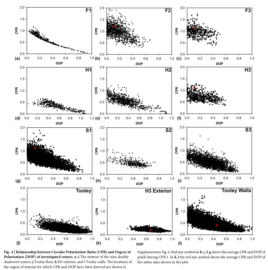
Fig. 4 — CPR vs DOP scatter plots] Each panel is a scatter plot for one crater, with DOP on the horizontal axis and CPR on the vertical axis. Each dot represents one radar pixel from that crater's interior. The red star on select plots marks the average CPR and DOP of all pixels where CPR exceeds 1 — the ice-candidate pixels. In craters F2, F3, H3, and S1, the red star sits in the upper-left zone — high CPR (above 1) AND low DOP (below 0.13). This upper-left cluster is the ice signature zone. In crater H1, Tooley floor, H3 exterior, and Tooley walls, there is no red star and the data clusters in the lower-right — low CPR and high DOP — consistent with surface scattering from rocky terrain, not ice. The contrast between F2's plot (red star clearly in upper-left) and H1's plot (no elevated CPR, data hugs the lower axis) visually demonstrates why the combined CPR + DOP criterion is more reliable than CPR alone. Any region with both CPR > 1 and DOP < 0.13 cannot be explained by surface roughness alone — it requires volumetric scattering, which is the radar signature of ice.
The analysis shows that crater rims, walls, ejecta, and impact melt flows consistently return high DOP values even when CPR occasionally exceeds 1 — confirming these are rough-surface signals, not ice. In the four ice-positive craters, the elevated-CPR regions return DOP of just 0.1–0.13. This combination points to genuine subsurface volumetric scattering.
The inferred subsurface ice assessment across all craters: F2 (Faustini) — Strong evidence | F3 (Faustini) — Likely | H3 (Haworth) — Partially likely | S1 (Shoemaker) — Partially likely | F1, H1, H2, S2, S3, Tooley — No evidence.
Key Finding: Crater F2 and Its Lobate-Rim Morphology
Crater F2 in Faustini stands out as the strongest detection in the study, supported by both radar data and morphological evidence.
Radar: F2 has the highest fraction of elevated CPR pixels (~47% of its interior), a peak CPR of 1.95, and a DOP of 0.1 — the lowest in the study, indicating the strongest volumetric scattering signal.
Morphology — the lobate rim: F2 displays a prominent lobate-rim morphology — a flow-like, lobed raised rim around the crater rather than a simple raised lip. This feature has previously been interpreted as evidence that an impactor struck a target containing subsurface ice: the impact excavated and mobilised ice-rich material, which flowed outward and froze in place, forming the lobed rim. Crater F2 has been previously identified as the most prominent lobate-rimmed crater among lunar polar craters studied to date.
Elevation geometry: The impact point of F2 sits at −2,744 m on the Faustini floor — approximately 180 m below the surrounding PSR floor surface (which ranges from −2,560 m to −2,755 m). The floor of F2 itself lies at −2,860 m, roughly 300 m beneath the Faustini floor's upper surface. This unusually deep impact geometry means the impactor likely penetrated down to a subsurface ice layer that sits at shallower depth, producing the observed lobate ejecta.
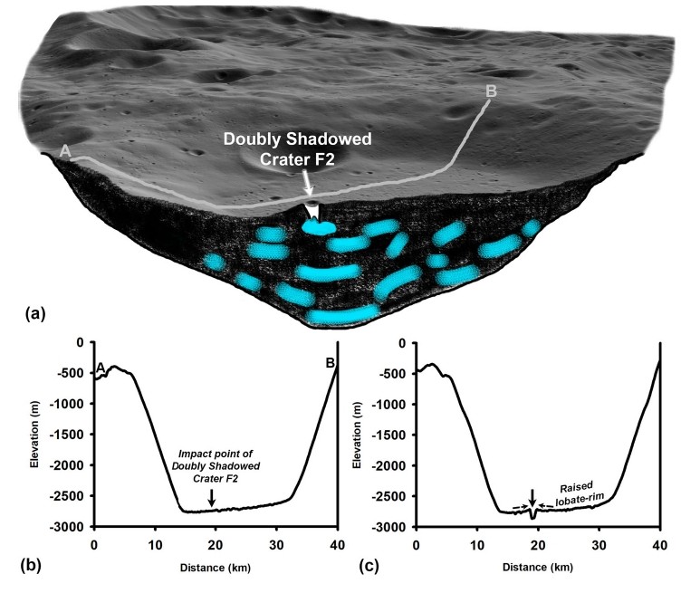
Fig. 5 — F2 lobate rim sketch + elevation profiles] Panel (a) is a conceptual 3D sketch of the Faustini permanently shadowed region, cut open to show the subsurface. Grey and black layers represent regolith and rock beneath the PSR floor. The cyan patches represent subsurface ice deposits. The small crater F2 is visible on the surface, with an arrow pointing to its impact point — showing it penetrated deep enough to reach the ice layer below. Panel (b) is an elevation profile along transect A–B across the full Faustini crater, showing the impact point of F2 at −2,744 m — approximately 180 m below the surrounding PSR floor. Panel (c) zooms into the elevation profile across F2 itself, clearly showing the raised lobate-rim as a distinct bump on the right side of the crater — this is the ice-rich ejected material that flowed outward and solidified. Together these panels explain the full formation story: the deep impact location reached subsurface ice, the ice mobilised on excavation, and it refroze as the distinctive lobate rim now visible around F2.
The raised rim of F2 is about 20–25 m high, providing effective shielding of the crater interior and maintaining persistently low annual minimum temperatures — supporting long-term ice retention beneath its floor to the present day.
Addressing the CPR Ambiguity
A long-standing challenge in lunar radar ice research is that elevated CPR can arise from two very different causes: volumetric scattering in ice, or double-bounce reflections from rough, rocky surfaces. This ambiguity has meant many earlier radar detections — including those from Chandrayaan-1's Mini-SAR and LRO's Mini-RF — were regarded as inconclusive.
The Chandrayaan-2 DFSAR study addresses this directly. In regions not expected to contain ice (crater rims, walls, ejecta, impact melt flows), the analysis consistently shows high DOP values, even when CPR occasionally exceeds 1. For example, the exterior impact melt flows around crater H3 show DOP as high as 0.67, and Tooley crater's walls average DOP of 0.45 — both well above the 0.13 threshold. In the four ice-positive craters, elevated-CPR regions show DOP of 0.1–0.13 — a combination that cannot be explained by surface roughness alone. This confirms the combined CPR + DOP criterion effectively separates genuine volumetric scattering from rough-surface artefacts.
Why Some Craters Show No Signal
The absence of radar ice signatures in five of the nine craters does not necessarily mean those craters are ice-free. The DFSAR instrument is sensitive primarily to the upper few metres of the subsurface. If ice deposits reside at depths greater than the radar's penetration depth, they would remain undetected in this analysis.
The study notes that subsurface ice distribution within PSRs appears to be spatially heterogeneous — not uniformly distributed. The presence and retention of ice in individual craters depends on their formation history, evolutionary stage, regolith properties, and local geological setting.
The absence of a lobate rim in F3, H3, and S1 — despite their radar ice signals — is also consistent with ice existing at a depth below the impactor's penetration depth: an impact that does not reach the ice layer would not produce a lobate rim, even if ice is present deeper down.
Depth-to-Diameter Ratio: Not a Reliable Standalone Indicator
Previous studies suggested that small craters formed in ice-bearing targets tend to have depth-to-diameter (d/D) ratios of around 0.16–0.21, because ice hardens the subsurface, reducing excavation depth. This study finds that d/D ratio alone is not a reliable indicator — all small doubly shadowed craters have d/D ratios below 0.16, but not all show elevated CPR. Tooley crater has the lowest d/D ratios (0.039–0.048) but shows no ice evidence at all. Morphological and radar polarimetric evidence together provide a more reliable picture.
Implications for Future Lunar Missions
Water-ice at the lunar poles is a key resource for future crewed exploration. It can be processed into drinking water, used for growing food, employed as radiation shielding, or split into hydrogen and oxygen for rocket propellant — potentially enabling the Moon to serve as a refuelling base for deeper space missions. Identifying specific, well-constrained ice-bearing locations is therefore critical for mission planning.
The doubly shadowed craters studied here — particularly F2 in Faustini — now represent well-characterised targets for future landing and In-Situ Resource Utilization (ISRU) activities. Several upcoming lunar South Pole missions from multiple space agencies will benefit from these refined ice maps.
The methodology itself — combining DFSAR polarimetric analysis with crater morphology and thermal modelling — provides a replicable framework for ice detection that can be applied to data from future lunar radar instruments.
About the Study
Title: Subsurface ice in doubly shadowed craters as revealed by Chandrayaan-2 dual frequency synthetic aperture radar
Authors: Rishitosh K. Sinha, Rajiv R. Bharti, Kinsuk Acharyya, Sanjay K. Mishra, Neeraj Srivastava & Anil Bhardwaj
Institution: Physical Research Laboratory (PRL), Ahmedabad (Department of Space, Government of India)
Journal: npj Space Exploration (Nature portfolio), Volume 2, Article 22 (2026)
DOI: 10.1038/s44453-026-00038-9 | Published: May 6, 2026
Data: Chandrayaan-2 DFSAR — https://pradan.issdc.gov.in/ch2 | ShadowCam — https://data.im-ldi.com/lunaserv.html
Archive: This article is archived at indianspaceflight.in https://www.indianspaceflight.in/archive/subsurface-ice-in-doubly-shadowed-craters-as-revealed-by-chandrayaan-2-dual-frequency-synthetic-aperture-radar
The Chandrayaan-2 DFSAR experiment was designed and developed by ISRO's Space Applications Centre (SAC), Ahmedabad.